The last hike of „TrekTours“ season will be like a time machine.


We will take you to the historical times not only of Merkinė city but also to the banks of the Nemunas river. Three routes: 11 km, 26 km, and 34 km, which will start with a stunning panorama from Merkinė mound (next to Vytaras Radzevičius’ bustling „World Pots”), will go down and connect the river Merkys with Nemunas, will lift you up 26 meters to an exclusive observation tower and lead you through the largest by area – Dzūkija National Park.


Get ready to end the autumn as the old Lithuanian rulers – Jogaila, and later Vladislovas Vaza, who lived here, would – hiking through the forests towards the goal with your own feet! Rest assured, because we will take care of everything else: full bellies and rest stops of spectacular beauty – guaranteed. Of course, as always, everything will be crowned with medals and fun. Hiking boots are your best weapon: do you have them ready?

ROUTE COMPARISON

11 KM

  • Start time from 08:00 to14:00
  • Starter pack
  • 2 rest and assistance stops
  • Water and tea
  • Snacks
  • -
  • Transfer if cutting short
  • Storage of belongings
  • Medal
  • E-diploma
  • Not suitable for baby strollers
  •  

26 KM

  • Start time from 08:00 to13:00
  • Starter pack
  • 6 rest and assistance stops
  • Water and tea
  • Snacks
  • Lunch
  • Transfer if cutting short
  • Storage of belongings
  • Medal
  • E-diploma
  • Not suitable for baby strollers
  •  

34 KM

  • Start time from 08:00 to12:00
  • Starter pack
  • 7 rest and assistance stops
  • Water and tea
  • Snacks
  • Lunch
  • Transfer if cutting short
  • Storage of belongings
  • Medal
  • E-diploma
  • Not suitable for baby strollers
  •  

11 km: You will start from the Merkinė mound and walk along one of the most beautiful confluences in Lithuania – of the Merkys and Nemunas rivers. Along the way, you will climb to the exquisite observation tower, where you will be able to gaze not only at the spectacular view but also at the real sheep that graze on the island. Next, you will hike towards lake Lauja through the unique forests of Dzūkija National Park and pass through the swampy edge of the Mikalaučiškės lake. From there, you will turn your way to the historic city of Merkinė, which was more important than Vilnius in the era of Jogaila because Merkinė castle was the strongest in Eastern Europe!

26 km: After descending from the Merkinė mound, you will take a historical path along one of the most impressive confluences in Lithuania – of the Merkys and Nemunas rivers. An exquisite observation tower awaits you, from which you can see not only the panorama of the city and the forest but also the sheep living on the island. Next, you will go through King Jogaila’s beloved forests and valleys, described and celebrated by Vincas Krėvė-Mickevičius. You will stop not only at the Krėve memorial but also at the nearby Tartar Museum. And you will return to the historic city of Merkinė, the importance of which, in the time of Jogaila, was greater than that of Vilnius itself.

34 km: This is the longest and historically richest route, as you will be hiking not only in the forests tread by King Jogaila but also on the former bottom of the river Nemunas, around the current oxbow lake. A route whose beauty lies in the works of Vincas Krėvė-Mickevičius, in Lithuanian, Tatar, Jewish folklore, and songs. It is not true that you will reach Druskininkai town, but you will indeed visit the villages of Netiesos (literally translates as „untruths”) and Druskininkai. History comes to life in this route, which will help you understand the Dzūkian heart: filled with forest serenity, rustling pine trees, and cheerful and undulating like continental dunes.

ORGANIZATORIAI

PARTNERIAI

In the autumn, we will meet with a bang and still pulsating summer energy nowhere else, but in the youngest city in Lithuania, less than 50 years old, and therefore the most energetic in Lithuania – Visaginas. It is the place where many cultures intersect: forests, lakes, and wetlands in different regions. We will combine everything into one hiking formula, the result of which is an atomic experience in Gražutė Regional Park.

In the autumn, we will meet with a bang and still pulsating summer energy nowhere else, but in the youngest city in Lithuania, less than 50 years old, and therefore the most energetic in Lithuania – Visaginas. It is the place where many cultures intersect: forests, lakes, and wetlands in different regions. We will combine everything into one hiking formula, the result of which is an atomic experience in Gražutė Regional Park.

ROUTE COMPARISON

13 KM

  • Start 07:00 – 13:00
  • Starter pack
  • 2 rest and assistance stops
  • Water
  • Snacks
  • -
  • Transfer if cutting short
  • Storage of belongings
  • E-diploma
  • Medal
  •  

27 KM

  • Start 07:00 – 13:00
  • Starter pack
  • 4 rest and assistance stops
  • Water and tea
  • Snacks
  • Lunch (takeaway)
  • Transfer if cutting short
  • Storage of belongings
  • E-diploma
  • Medal
  •  

36 KM

  • Start 07:00 – 11:00
  • Starter pack
  • 6 rest and assistance stops
  • Water and tea
  • Snacks
  • Lunch (takeaway)
  • Transfer if cutting short
  • Storage of belongings
  • E-diploma
  • Medal
  •  

47 KM

  • Start 07:00 – 10:00
  • Starter pack
  • 7 rest and assistance stops
  • Water and tea
  • Snacks
  • Lunch (takeaway)
  • Transfer if cutting short
  • Storage of belongings
  • E-diploma
  • Medal
  •  

58 KM

  • Start 07:00 – 09:00
  • Starter pack
  • 8 rest and assistance stops
  • Water and tea
  • Snacks
  • Lunch (takeaway)
  • Transfer if cutting short
  • Storage of belongings
  • E-diploma
  • Medal
  •  

DISCOUNTS

Pupils, seniors and children up to 7 years of old can choose a price type with a discount.
Durig the collection of starter packs all participants registered with a discount will be asked to provide a document confirming their status.

You will start on the beach of Lake Visaginas, and from there you will exit to the wide streets of the city, which were adapted for quick evacuation. The architecture of the Soviet city plan is perfectly intertwined in the forest, so you won’t even feel like you’re in an actual forest and will soon reach Lake Smalvas. You will continue walking through the woods towards the spectacularly shaped Lake Trilypis. Its shoreline is especially winding, and the two straits divide the lake into three parts. Finally, you will reach Aklažeris and return through beautiful forests to Visaginas beach, where you will have nuclear entertainment and get to have unique personal experiences in the surroundings of the city!

Like the 13 km hikers, you will go with them at the beginning, but after reaching Lake Smalva, you will move towards the most transparent and cleanest lake in Lithuania – Šventas. The lake has neither tributaries nor springs, making it unique in its water level fluctuations. It is also rich in rare plant and animal species. If you go further, you will reach another lake – Dūkštas, and walking along its shores, you will pass between two more lakes in the deep forest: Karačiunka and Baltoji. From here, you will move towards the finish line on Visaginas beach, where you will have nuclear entertainment and get to have unique personal experiences in the surroundings of the city!

You will start with everyone, but unlike the 13 and 27 km hikers, you will be the only ones to bypass the whole of Lake Šventas. It has no inflows and no outflows, making it unique in its water level fluctuations. It is also rich in rare plant and animal species. If you go further, you will reach another lake – Dūkštas, and walking along its shores, through the deep forest, you will pass between two more lakes: Karačiunka and Baltas. Here, you will already move towards the finish line on Visaginas beach, where you will have nuclear entertainment and get to have unique personal experiences in the surroundings of the city!

The start of the hike is the same as for all hikers, but there will be so many lakes on your trail that it will be difficult to count them! At the most transparent and cleanest lake in Lithuania – Šventas, you will go towards the forested Davigiliai lake, further on Velnežeris, Samavas, which has as many as 6 islands, you will reach Asavas, where live as many as 10 species of fish. Later you will arrive at the slightly smaller lake Luodykštis. And this is not the end! Because you will still get to Dūkštas, Karačiunka, Baltas, and finally Lake Visaginas, where you will have nuclear entertainment and get to have unique personal experiences in the surroundings of the city!

This trail is for true hiking gourmets who love long experiences, changing terrain, dense forests, and unique architectural monuments. You will start the hike like everyone else, but it is you who will get to feel the most contrast of the forests: from deciduous to conifers, which hide lakes and swamps. You will pass Smalva, Šventas – the cleanest and most transparent lake in Lithuania, Davigiliai, Velnežeris, Samava, Asavėlis, from which you will reach the exclusive Salakas Church, the Jewish cemetery and the only ones will pass the impressive Mergežeris swamp towards Lake Luodis. And from it: Dūkštas, Karačiunka, Baltas lakes and, finally, you will arrive at the Visaginas lake. Here you will find nuclear entertainment and get to have unique personal experiences in the city’s surroundings and a well-deserved rest!

THE PROCESS OF THE EVENT

ATVYKIMO VIETA
All participants must arrive at the start area – Visagino ežero paplūdimys, Parko g. 16, Visaginas 31133, Visaginas, Lietuva (GPS: 55.59509, 26.42764).

REGISTRATION
After arriving to the start area, your ticket will be scanned (mobile versions accepted) and you will be handed out your starting package, which contains:
– control bracelet (Only participants with bracelets will be serviced at the stops);
– participant pass and a map with directions and support contacts;
– other crucial information and items.

STARTING
After registration, you are allowed to begin the hike on the designated time for your route, which can be found in the route comparison area.

HIKING
Rest and assistance stops will be set up all across the hike route, in which you are required to check-in with your participant pass. You will also be able to replenish your water supplies, have a cup of tea, grab a snack and if need be, receive first medical assistance.

TRANSPORTATION AFTER TERMINATING YOUR HIKE EARLY
Participants wishing to terminate their hike early will have to get to the nearest rest and assistance stop. From there, they will be brought back to the start area by designated vehicles. At the finish zone, participants should present their participant pass to volunteers and will receive a diploma with the exact number of kilometres walked.

FINISHING
All of the hike routes are radial, thus you will start and finish and the same place – Visagino ežero paplūdimys, Parko g. 16, Visaginas 31133, Visaginas, Lietuva (GPS: 55.59509, 26.42764). Here, the participants who have successfully completed their chosen route will be awarded with nominal diplomas (on demand) and medals. However, the hike is not a race, thus your time will not be recorded and there will be no rewards for the first hikers crossing the finish line.

When registering, all participants agree with hike regulations.


WHAT IS INCLUDED IN THE PARTICIPANTS PACKET?


passport ico

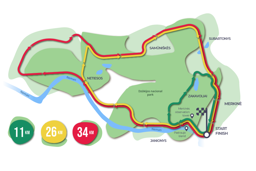
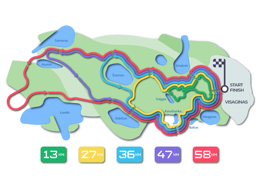
PARTICIPANT PASS WITH ROUTE MAP
Check-in marking table, orientation map and useful information.

watter ico

WATER
Bottled water at start zone and refill in most stops.

pitstop ico

REST AND ASSISTANCE STOPS
Every 4-5 km set up stop for participant check-in, services and rest.

tea ico

TEA
In most stops.


snack ico

SNACKS
For all participants.

hot meal ico

HOT FOOD
For 27 km, 36 km, 47 km and 58 km participants.

apyranke fone-30 (1)

PARTICIPANTS BRACELET
For participants identification.

medicine ico

FIRST AID
First aid kit in each stop.


transport ico

TRANSPORTATION
Back to the start area if it is decided to terminate the hike.

belongings ico

STORAGE OF BELONGINGS
In the starting area.

medal ico

MEDAL
After successfully completing the chosen route.

diploma ico

E-DIPLOMA
Nominal with marked number of kilometres walked.

ARRIVAL

START:

Visagino ežero paplūdimys, Parko g. 16, Visaginas 31133, Visaginas, Lietuva (GPS: 55.59509, 26.42764)

STARTING TIME:
13 KM: 07:00 – 13:00
27 KM: 07:00 – 13:00
36 KM: 07:00 – 11:00
47 KM: 07:00 – 10:00
58 KM: 07:00 – 09:00

ORGANIZERS